Hawaii 2018 – exciting but not too exciting!
I have been asked to write a bit about my recent family holiday to Hawai’i—not because you really want to know about my family holiday, but because of the recent seismic activity that started while we were there.
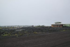
Having arrived in Hawai’i (the Big Island) on Friday 27th April, we got to our accommodation in Volcano Village on Sun 29th. This is just on the northern edge of the Volcanoes National Park which contains Kilauea, the currently most active volcano on Hawai’i. On Monday 30th we spent the day in the south-eastern corner (Pahoa area) visiting the Lava Tree State Monument, and driving as far west along the coast road (Highway 137) that it is possible to drive. The lava flows between 1986 and 2004 cut that road off as the lava reached the sea. The house insurance situation in Hawaii is that you still own the land if your house is overrun by lava, (even though it might be 10m below the lava), so we found people rebuilding houses there now on bare lava (see below).
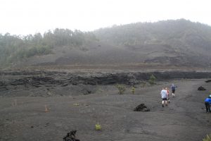
The next day was spent in Volcanoes National Park. We walked through a crater next to the main Kilauea caldera, on top of the lava lake (thankfully solidified but steaming gently here and there) called Kilauea Iki (see below) and visited the Thurston Lava Tube.
All ok so far—no seismic activity. But on Thursday 3rd we drove along the Saddle Road, visiting the highest peak on Hawai’i (Mauna Kea) which houses an observatory. As we were driving, we saw a curious pinkish plume in the sky off to the south-east, and on checking, found that this was coming from the Pu’u O’o crater (between Kilauea and Pahoa) – a rock fall into the crater causing it. No big deal we thought—it didn’t last long.
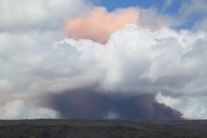
The next day though—everything changed. Once again in Volcanoes National Park, we drove down Chain of Craters Road, to the south-east, stopping at Pu’u Loa to see the petroglyphs (figures etched in the lava). While on the boardwalk there, we all seemed to trip—at exactly the same time—and realised that actually this was due to an earthquake (5.3 on the Richter scale). A few minutes later a cloud of pink ash/dust could be seen to the north of us coming out of Pu’u O’o. Ok—quite exciting, but still no big deal.
The big deal happened an hour or so later when we were at the coast, at the end of Chain of Craters Road, where it would have joined up with Highway 137 to the east had the 1986-2004 lava flow not cut it off. We had just parked when the big earthquake happened. This was 6.9 on the Richter scale, and went on for over 10 seconds, knocking me off my feet. What a scary (and yet exhilarating) experience to have the ground move under your feet, and keep on moving! Part of the cliffs just there fell into the sea and Jen (who you might remember has a PhD in volcanology) started to herd us back to the car because she realised that, depending on where the epicentre was, there might be a tsunami. A little while later the Park Rangers arrived and started moving everyone out of the Park—or at least to much higher up where we would be safe. Pu’u O’o was now producing more dust/ash (see below).
So we were the first to set off—finding that we had to stop the car a number of times to move rocks off the road that had been shaken down from the sides.
We checked the internet on getting back to Volcano Village, Jen looking at the data rather than what you see on the news, and found that this was a significant seismic event, with the main crater in Kilauea caldera (Halema’uma’u) also now producing dust/ash.
Over the next few days there were many aftershocks. Our house was made of wood and just shook and groaned each time with pictures going crooked, cupboard doors coming open and things falling off shelves. Back in Pahoa, fissures were opening up, producing more and more lava as the days went by. There are around 20 fissures now (20/5/18) and the lava has flowed all the way to the sea, cutting off Highway 137 again— east of the place where it was cut off before, where we had just been. The triangle between Highways 130, 132 and 137 has now been partially evacuated, a number of dwellings destroyed, and one person seriously injured by blobs of lava being spurted out of a fissure. He was just sitting on his third floor balcony so it had been thrown quite a distance!
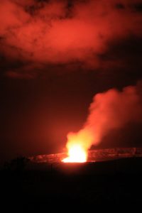
Volcanoes National Park is partially closed—some of the roads still accessible, but trails that we had walked earlier in the week are now closed, and the overlook for Halema’uma’u is also closed. They did open the overlook in the Park again on Sunday 6th, so we went along in the evening, and found that the level of lava in the lava lake had dropped around 700’, the lava having moved towards the east, along the Eastern Rift Zone, contributing to the eruption in Pahoa. Although we couldn’t see any lava, the red glow from it down below was reflected in the emissions and clouds (see below).
We flew to Honolulu a couple of days later.
I am left with an overwhelming sense of awe at God’s creation, and gratitude that I was there for the start of this amazing seismic event—we arrived just at the right time and left before it got worse. Sadly thousands of residents of the Pahoa district are not so lucky.
Sue T
There are lots of photos of the trip on Facebook if you have an account— just search for ‘Sue Truby’ and look at the ‘Hawaii 2018’ album.